View in other NatureServe Network Field Guides
NatureServe
Montana
Utah
Wyoming
Idaho
Wisconsin
British Columbia
South Carolina
Yukon
California
New York
Torrey Bitterweed - Hymenoxys torreyana
Other Names:
Tetraneuris torreyana
General Description
Caudex branched, mat-forming. Stems simple, erect, scapose, 3–10 cm. Herbage punctate-glandular, villous on stem and leaf bases. Leaf blades narrowly oblanceolate, entire, 1–5, cm long. Heads solitary; involucres 7–11 mm high; phyllaries subequal, lanceolate to ovate, scarious-margined, glandular, villous. Ray ligules 7–11 mm long. Disk corollas 4–5 mm long, glandular. Achenes 3–4 mm long; pappus scales 5–7 (
Lesica et al. 2012. Manual of Montana Vascular Plants. BRIT Press. Fort Worth, TX).
Lesica (2012) treats this species in the genus
Tetraneuris.
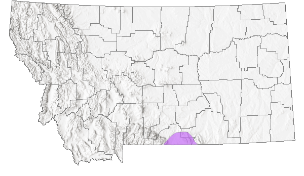
Species Range
Montana Range
Range Descriptions
 Native
Range Comments
Carbon County, MT; WY, UT and CO (Lesica et al. 2012. Manual of Montana Vascular Plants. BRIT Press. Fort Worth, TX).
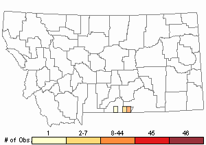
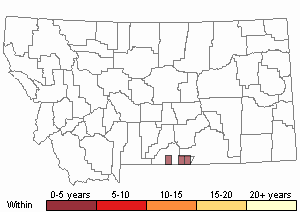
Observations in Montana Natural Heritage Program Database
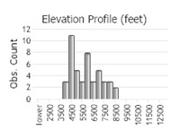
Number of Observations: 67
(Click on the following maps and charts to see full sized version)
Map Help and Descriptions
Relative Density
Recency

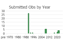
 (Observations spanning multiple months or years are excluded from time charts)
Habitat
Open ridges and meadows at low to high elevations in the mountains, often on limestone-derived soil in juniper woodlands, mountain mahogany woodland, and cushion plant grasslands.
Stewardship Responsibility
References
- Literature Cited AboveLegend:
 View Online Publication
- Lesica, P., M.T. Lavin, and P.F. Stickney. 2012. Manual of Montana Vascular Plants. Fort Worth, TX: BRIT Press. viii + 771 p.
- Additional ReferencesLegend: View Online Publication
Do you know of a citation we're missing?- Lesica, P. and P.L. Achuff. 1992. Distribution of vascular plant species of special concern and limited distribution in the Pryor Mountain desert, Carbon County, Montana. Unpublished report to the Bureau of Land Management. Montana Natural Heritage Program, Helena, MT. 105 pp.
- Lesica, P., M.T. Lavin, and P.F. Stickney. 2022. Manual of Montana Vascular Plants, Second Edition. Fort Worth, TX: BRIT Press. viii + 779 p.
- Web Search Engines for Articles on "Torrey Bitterweed"